Home >
Ohio's Canal System
Ohio was only 21 years old as a state when the Ohio Legislature approved plans and authorized funding for an Ohio Canal system to be built. The year was 1825. This wasn't a spur of the moment decision on the legislature's part. In 1822 the legislature commission a study to test the feasibility survey to see if it would be possible to build canals throughout the state to connect to the major waterways namely the Ohio River and Lake Erie.
In 1820 there were estimated to be 580,000 residents then living in the state, and most of these were involved in agriculture. The problem with the modern agriculture of the day was that they had more produce than they could use. The best way to keep the family farm profitable was to sell the excess to places that didn't have so much agriculture.
Eight years earlier work had begun on building a canal that connected Lake Erie with the Hudson River and ultimately New York City. That opened lots of possibilities and the opportunity for Ohio's farmers and businessmen to sell their goods to a much larger market.
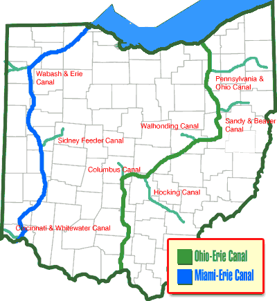
When Ohio's first canal engineers located the route this new transportation system was to take, they weren't concerned so much with providing the fastest and most direct route between two points, as they were with providing a dependable means of transportation, to as many Ohio residents as possible. Some politicians even went as far as suggesting the most advantageous route would be a diagonal route from the northeast to the southwest Ohio. Such a canal would pass through or near the Ohio's major population centers. Such a route may have satisfied the most people, it didn't satisfy the engineers. The proposed canal cut the state's watershed in such a manner that it would have been impossible to supply it with water. A compromise was finally decided upon which resulted in two main canals being built, one in the east and one in the west.
By connecting the Ohio frontier with New York and New Orleans via these two canal systems, the Ohio & Erie Canal and the Miami & Erie canals helped people and products flow across America, fueling westward expansion, a national market economy and regional industrial might for Ohio.
The canal system reached its peak in revenue generation in 1855. At that time the Ohio canal system consisted of almost 1000 miles. It was at this time that railroads were becoming a cheaper and faster way of transporting goods across the country. The increased use of the rail system and later the highway system brought a slow death to the canal system. But it took a natural disaster to completely end the Ohio canal system in March of 1913 when Ohio experienced a record winter snowfall and then unusually heavy rains fell that caused widespread flooding throughout the state. This flooding destroyed many of the canal systems raised banks and locks. Ohio's canal system was dead.
Today less than 20% of the original canal system is still owned by the state and this is spread throughout the state in small plots of less than an acre. Recent interest in the canals has attracted the attention of small Ohio communities to use what remains of the canals as attractions.
The feeder lakes... today's great water attractions
Several lakes still remain today as a result of Ohio's canal system. St. Marys, Indian Lake, Lake Loramie, Guilford and Buckeye lakes were to be developed as part of the project. These were manmade lakes that helped feed the canal with water during the dry periods. 33,000 acres of reservoir surface were built between 1825 and 1847 to make the Ohio canal system possible.
Buckeye Lake
Construction began in 1826 and completed in 1830. At that time is was called the Licking Summit Reservoir. It didn't become known as Buckeye Lake until 1894 when the Ohio General Assembly established these feeder lakes as state parks.
Guildford Lake
Guilford Lake was constructed as a canal feeder reservoir for the Sandy and Beaver Canal in 1834. The Sandy and Beaver Canal was one of many feeder canals. The Sandy and Beaver Canal was a feeder to the Ohio and Erie Canal and is located in Columbiana County.
Grand Lake
In 1837, work commenced on the reservoir for the Miami-Erie canal to maintain the canal’s four-foot water depth. Workers using hand tools were paid 35 cents a day and a jigger of whiskey to keep malaria away. At its completion in 1845, 13,500-acre Grand Lake was the largest man-made lake in the world. The lake was connected to the canal by a three-mile feeder.
Lake Loramie
Lake Loramie
was originally constructed in 1844-45 as a storage reservoir for the Miami-Erie Canal system. A short feeder canal connected Lake Loramie with the main canal. Lake Loramie is located south east of Grand Lake St. Marys.
Indian Lake
Indian Lake was built in 1851 as a feeder lake for the Miami and Erie Canal to maintain the required four-foot water depth throughout the canal system

The Ohio Canals
Ohio & Erie Canal
Miami & Erie Canal
Wabash & Erie Canal
Warren County Canal
Cincinnati & Whitewater Canal
Milan Canal
Columbus Feeder
Granville Feeder
Trenton Feeder
Hocking Valley Canal
Walhonding Canal
Muskingum Improvement
Sandy & Beaver Canal
Pennsylvania & Ohio Canal
Middlebury Branch Canal
Nimishillen & Sandy Canal
Sidney Feeder
See also:
