

The Hocking Canal was authorized in 1836 as a branch of the Ohio and Erie Canal with which it made a junction at Carroll Ohio and traveled south with its terminus in Athens. It was intended to tap the coal and salt fields of the Hocking Valley and traffic in those bulk commodities was substantial. Coal primarily came out of the coal mines around Nelsonville, and there were several salt processors located in the Athens area.
A privately built canal, 9 miles long, between Carroll and Lancaster, was taken over by the State of Ohio, when the Hocking Canal was authorized and enlarged to become part of the Hocking Canal. Partial abandonment of 7 miles of the canal below Chauncey to Athens, including the Athens terminal took place in 1874. Final abandonment and lease of some canal property to the the Hocking Valley Railroad took place in 1894.
 The Hocking Canal used towpath navigation with both horses and mule power. It was constructed to the dimensions and standards set out by the Ohio and Erie Canal which it was a branch. In addition to 27 lift locks, there were 5 guard locks, 34 culverts, 8 feeder and slack water dams and one aqueduct that spanned about 80 feet over Monday Creek. Cost upon completion in 1843 was estimated to be about $947,670.25.
Later, long after the canal had been abandoned and replaced with the railroad, a new invention, the automobile began to make its presence known. In the mid 1930s, after years of abandonment, the Hocking Canal bed was filled in many places and paved over to create State Route 33 that extended south to the Ohio River.
In Nelsonville, some of the cut stone used in constructing the locks, were used to help strengthen the levee along the Hocking River. Some were used as bleachers at Estel Crabtree Field, the baseball field and can still be seen today.
Plans for extending the feeder canal from Carroll did not start out with plans to build a canal. The initial plans called for only improving the Hocking River channel to accommodate the canal boats. However, because of the treacherous rapids and water falls on the Hocking River became known to the designers, plans had to be drawn up for the canal.
The Hocking Canal was completed to Nelsonville in 1840. Extending it from Nelsonville to Athens would take another 3 years. It was this initial completion to Nelsonville that benefited this area the most. Businessmen now had ways of exporting coal dug out of nearby mines to the factories and homes in Columbus. Besides shipping coal north, salt, pork and wood products also went north. On return trips, the canals brought manufactured products south.
There were 3 types of canal boats on the Hocking Canal. Most of the were cargo boats designed to carry the crew and mule teams and nothing else. Some were family boats that were more often than not, cargo boats. The difference was the family boats had space for the captain and his family. The 3rd type were packet boats which transported mail and passengers, but these were used much less frequently.
The cargo boats would average about 2 - 2.5 miles per hour and the packet boats, although much faster, were restricted to no more than 4 miles per hour so their wake did not harm the shore line. Mules were used for the cargo boats and horses for the packet boats.
During the winter months when the canal would freeze over, the canal boats would tie up in areas called basins, which were nothing more than large mostly man-made ponds that were created along the canal route. Because the canals did not have running water as it would be in a river, the canals would freeze over much quicker. This stopped canal traffic until the weather warmed in late winter or early spring.
In one account, on July 19, 1863, after having lost 2/3s of his men in a crushing defeat on Buffington Island on the Ohio River, a confederate cavalry of 400 led by General John Morgan entered Nelsonville and burned most of the canal boats tied up in the canal basin. The rebels looted the stores in Nelsonville and rode off with all the horses they could find. They also set fire to a covered bridge to slow down the Union forces pursuing them. However, the townspeople quickly put out the fire within a few hours keeping it intact for the Union cavalry to cross over. Morgan would be captured 4 months later near Salineville which is located just north of Steubenville, Ohio.

The Hocking Canal ran from Carroll, Ohio (located southeast of Columbus about 13 miles from I-270 on SR 33). From Carroll the canal ran 56 miles through Lancaster, Sugar Grove, Logan, Nelsonville, Chauncey and Athens where the canal ended. There were a total of 26 numbered Lift Locks on the route and 5 Guard Locks used mostly to withhold water in the basins. Overall from Carroll to Athens there was a 202 foot change in elevation.

Part of the Hocking Canal feeder system extended the lateral canal into Fairfield County. Stone masonry locks 11, 12 and 13 and a relocated covered bridge.
Lockville, Ohio was the site of 7 locks along the Ohio-Erie Canal. Lockville Park, part of the Fairfield County Historic Parks system, has the stone masonry of locks 11, 12 and 13 which can be easily viewed by visitors along Pickerington Road. Picnicking facilities are available.

An added feature of the park is the presence of the relocated Hartman II Covered Bridge one of the 18 covered bridges that are still in existence in Fairfield County, Ohio.
Lock 17 is on County Road 25 (Haydenville Road, which is actually the old SR33) right at where CR25 intersects SR33.

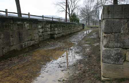
Lock #19 is located just north of Nelsonville on the west side of SR33. There is a pull-off and information kiosk.

Hocking Canal Lock #19, built in 1841

Canal Lock #19