BlackhandGorge
 Over time the Licking River has created a gorge in the sandstone of Licking County Ohio. On one of the cliff faces was a mysterious black hand. It was an Indian petroglyph painted on the north side of the Licking River.
Long before European settlers arrived, the black hand was a symbol used by American Indians. Pioneers were told the symbol was to mark an area of peace and supposedly, in this area, no hand should be raised against another, similar to Flint Ridge just miles away where all tribes gathered in peace.
In 1828 while building a portion of the Ohio Erie Canal the black hand petroglyph was lost in an explosion. The location of where the black hand existed is still known today and is marked along the trail. The canal days passed and by 1851 the Central Ohio Railway steamed through the gorge. In 1903 it was joined by an electric interurban line which connected the communities of Newark and Granville. The last interurban ran in February of 1929.
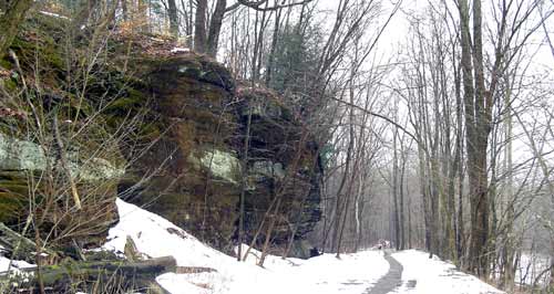
 Today, although the hand is gone and with it canal traffic and sound of those long ago trains, what is left is the beauty of the gorge. In 1975 this serene passage became a Ohio State Nature Preserve. The 970 acres hold many trails and offers a 4 mile blacktopped walkway and bike path. There are several trails that allow you to hike up above to the tops of the hills for a beautiful view of the river and the exposed rock. Besides the Licking River rambling through the gorge, you will see the remains of the canal towpath and lock and will follow the old train bed through the beautiful scenery of Blackhand Gorge. There are also abandoned quarries in the area. I’ve been there during the summer and in March while the snow was still on the ground. It is a beautiful place no matter what the season.

Blackhand Gorge is located just 8 miles east of Newark. Take Rt. 16 East from Newark, turn right onto Route 146 in 1/4 of a mile turn onto County Road 273 and follow it to Blackhand Gorge. The preserve's entrance and parking lot are 1 1/2 mile south on County Road 273 just outside of Toboso.

Blackhand Gorge Sandstone
The walls of the gorge are made up of exposed sandstone which is common to much of Ohio. The sandstone found at Blackhand Gorge is about 200 feet thick with varying layers of both hard and soft sandstone. Where the stone is softer, erosion is faster, and thus creates cut back caves and ledges throughout the park. The sandstone is made up mostly of white quartz grains.
In this area, the sandstone was created millions of years ago when the land was covered by a large body of water. Sedimentation in the water settled to the bottom of the water and became compacted over time forming the sandstone layer. Much of the sandstone that exists in eastern Ohio is referred to as Blackhand Sandstone.
Click here for a PDF map of the area prepared by the Ohio Division of Natural Areas and Preserves>>


